California has an almost impossible amount of natural beauty. Some of its most jaw-dropping beauty can be found in Big Sur. Big Sur is a stretch of coast in Central California from Carmel to San Simeon and is renowned for its rugged natural beauty. This coastline is one of the main highlights of driving the Pacific Coast Highway and also features the famous Bixby Bridge.
Most of the activities in Big Sur revolve around its natural beauty, for good reason. On any given day, you can drive the coastline and see cars pulled over all along the road to marvel at and photograph the coastline. There are also some state parks with campsites, hiking trails and beach access.
Andrew Molera State Park in Big Sur is one such place, and home to an amazing day hike. I’ve done this hike twice, and would highly recommend it to anyone looking for a moderate hike that will take you to bluffs with gorgeous lookouts and private beaches.
This is what it’s like to hike the best day hiking trail in Big Sur:
Trail Parking
This trail is actually a bit of a Frankenstein hike because it’s a loop comprised of multiple trails around park. The eight-mile moderate hike looks through the Ridge Trail, Panorama Trail and Creamery Meadow Bluffs.
To get to the trailhead, drive to the parking lot for Andrew Molera State Park. It costs $10 cash to park in the lot, which you’ll give to an attendant or put in a box if there’s no attendant. There are bathrooms in the parking lot. You can also get a map of the park here. If you don’t have cash, or it the lot is full, you can also try to park on the highway.
When you get to the parking lot, take a minute to use the restroom and make sure you have enough sunscreen and bug spray on your body. Some sections of the trail can be pretty overgrown, and there is a danger of ticks, so make sure to wear repellent. It’s also a good idea to periodically check for ticks around your ankles, especially around the rim of your pants and shoes as you hike.
Getting to the Trailhead
The trailhead is only a few feet from the parking lot. As you exit the parking lot, turn right and walk towards a small river. During certain times of year, there is a pedestrian bridge across the river you can use to get to the other side. If the bridge isn’t available, you’ll need to remove your shoes and wade into the water.
I’ve done this hike in May and July, and the pedestrian bridge was out when I hiked it in May. The water isn’t too deep, but it is cold, so be prepared to wade through chilly, shallow water. The most unpleasant part was having to remove my hiking boots and socks then put them on my wet feet.
I’d recommend bringing a microfiber towel on this hike to dry off your feet and legs if the pedestrian bridge is out. Also, make sure you can easily roll up your hiking pants. I might even consider wearing sandals to the start of the trailhead for easy removal.
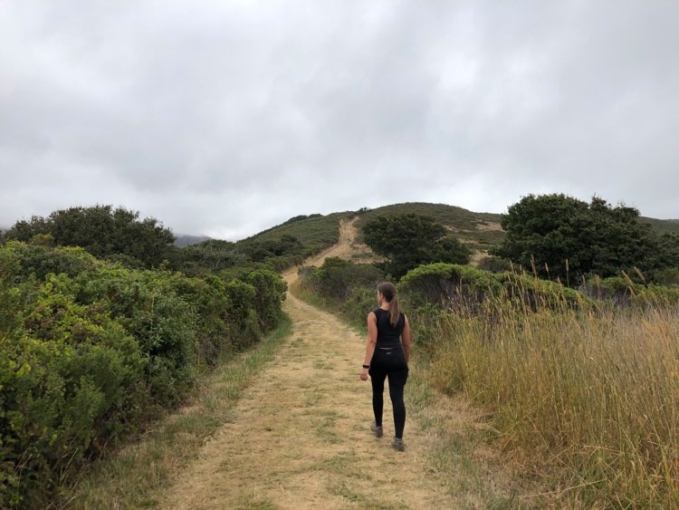
Once you’ve crossed this stream, you’re at the start of the trail! All Trails recommends taking the loop counter-clockwise starting on the Creamery Meadow Bluffs Trail. This way will have you start walking through the bluffs and along the beach and end walking through the woods. However, I prefer going clockwise. Taking the loop clockwise will take you uphill through the redwood forest, then opens up into incredible coast views.
Starting the Trail
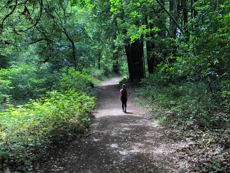
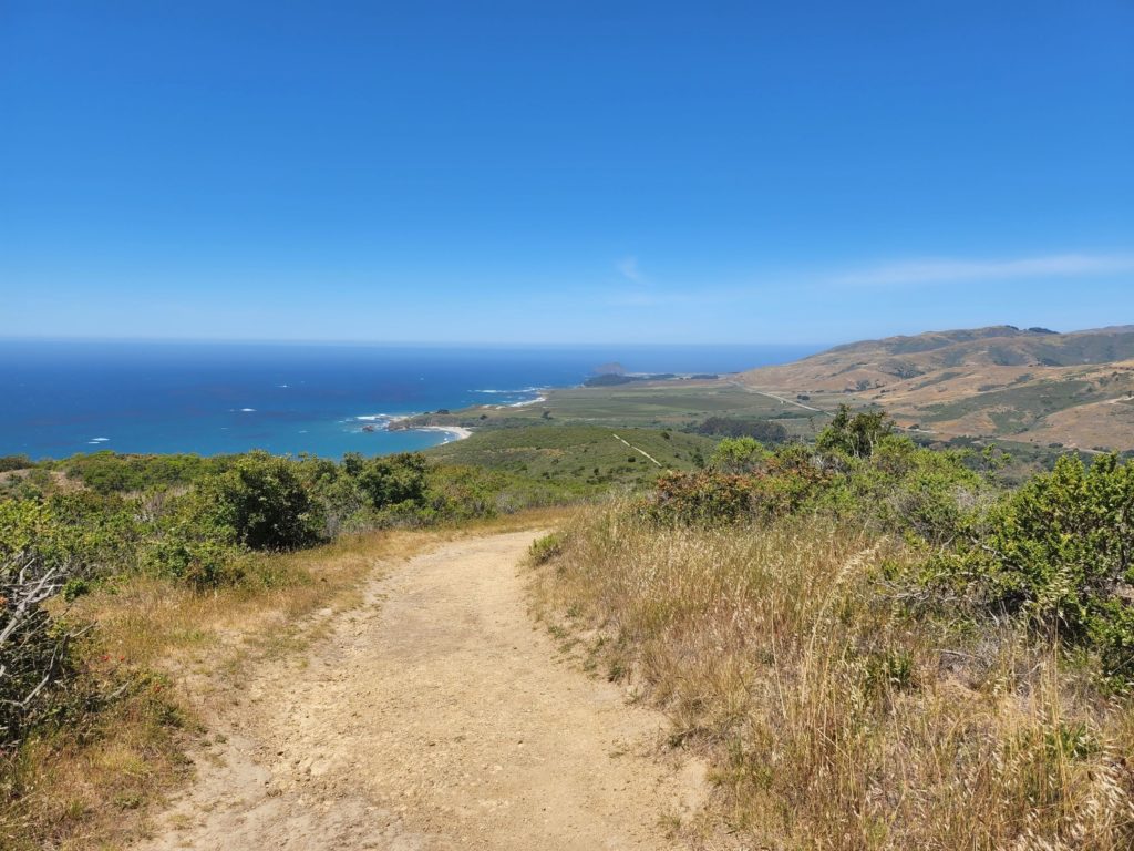
If you do go clockwise, you’ll start with a steady incline for the first mile or so. Walk up the hill and into the redwood forest. Passing giant redwoods covered in moss makes it seem like a different world. You might even forget you’re on the coast. Continue walking through the forest, and you’ll come out onto the Panorama Trail.
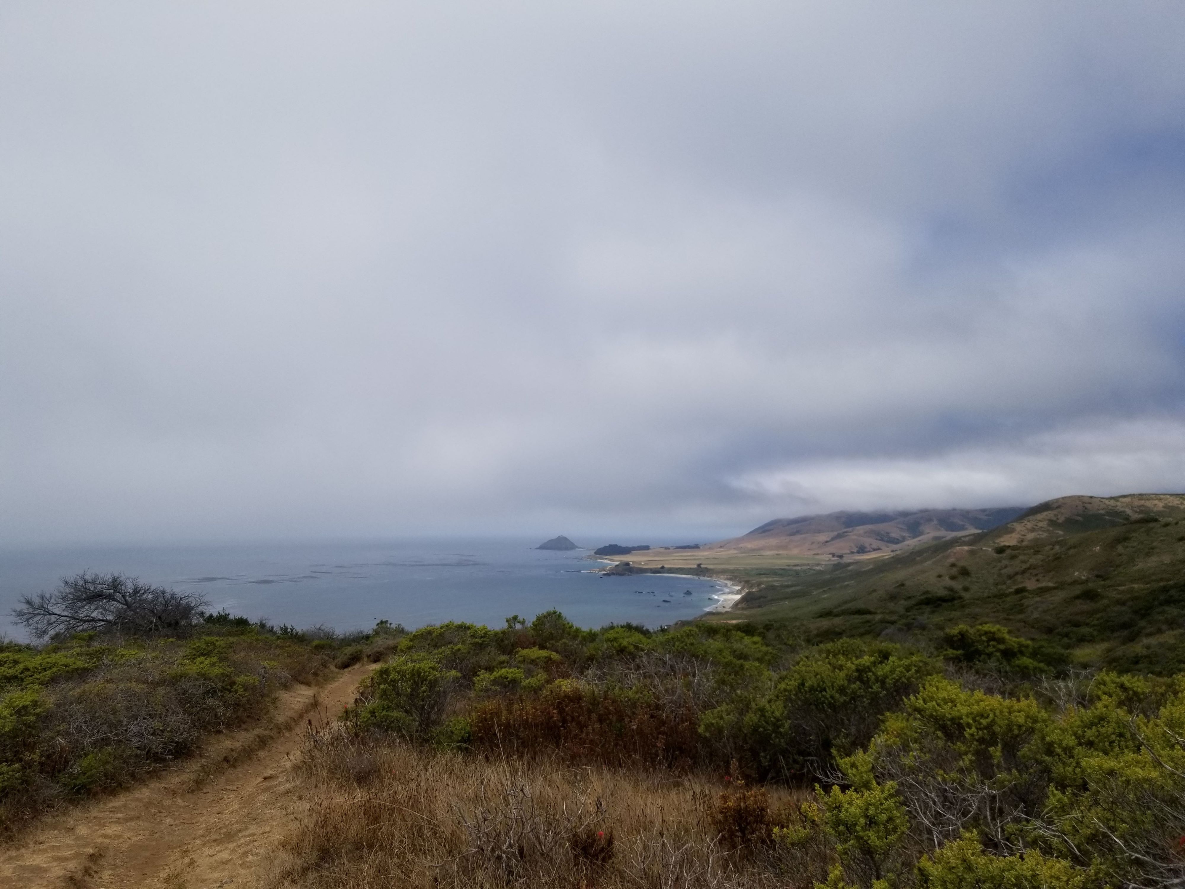
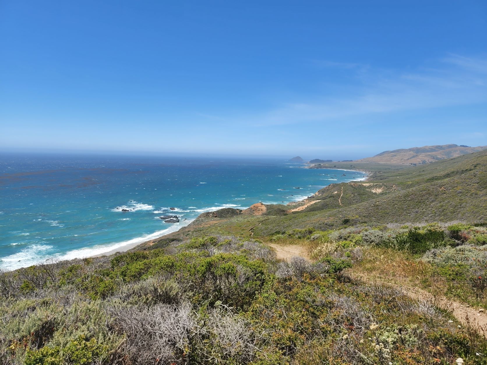
Soon, the trees will give way, and you’ll get your first glimpses of the coastline from above. The first viewpoint is an area called Panorama Point. As you might have guessed, it gives panoramic views of the coast.
As you continue following the trail, the coastline will become even more visible. You’ll enjoy views of the water against the rugged cliffs of California’s central coast. It’s beautiful in both sunny and cloudy weather.
Finding the Hidden Beach
From Panorama Point, continue following the trail. There are somewhat steep downhill sections at this point, but nothing too difficult. However, the trail can be overgrown at certain times of the year. One thing to watch out for at this point in the trail is the poison oak overgrowth that can crowd the trail. Andrew Molera State Park has a higher-than-average concentration of poison oak, and this point in the trail has the highest chance of brushing up against it. Cover exposed skin and try to avoid it as much as possible.
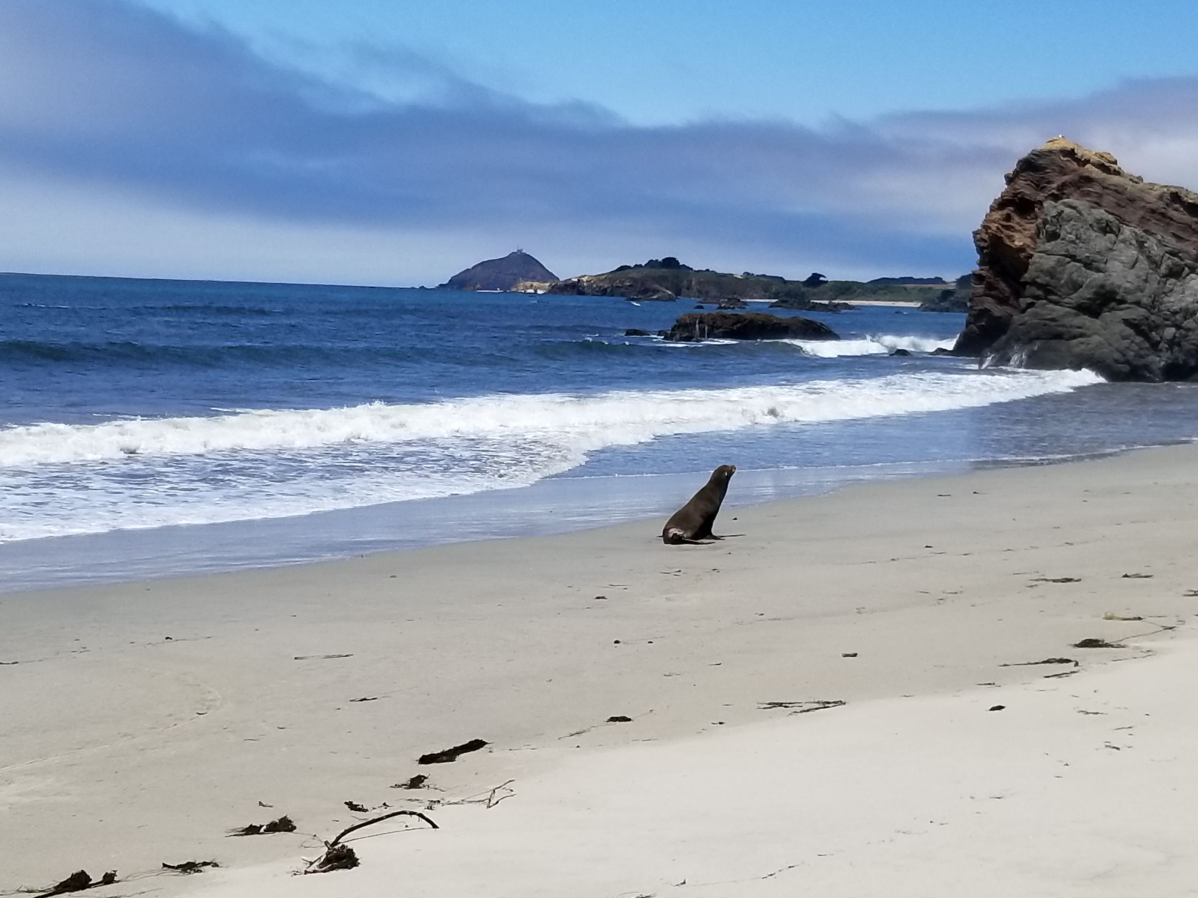
About halfway through the loop, there is a hidden beach. The path will coincide with a stretch of driftwood. If you cross this driftwood, it will take you to a secluded beach that’s only possible to reach via this trail.
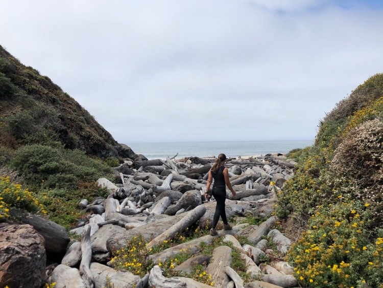
Depending on the tide, you might be able to walk along the beach to an even more secluded section. When we hiked the trail in July, the tide in the late morning/early afternoon was low enough to get away from the other few hikers on the trail to the point where it was just us and the seals on the nearby rocks in the ocean. However, in May, the tide was too high to get back to this exact spot.
Finishing the Trail
To get back to the trail, go back the way you came across the driftwood. Climb back up the Creamery Meadow Bluff trail and enjoy walking along the bluffs. The trail is mostly flat with some mild climbs and descents. This part of trail is clearer than the previous sections, with small vegetation close to the ground. However, make sure to continue watching out for poison oak.
This part of the trail has the most spectacular views of the coast and is the #1 reason I recommend hiking this loop backwards. The sweeping views of the ocean lapping along the coastline feels so rewarding after hiking the full trail.
Before you know it, you’ll be back at the river crossing. Cross the bridge or wade across the river, and you’re done with the best day hike in Big Sur.
After your hike, you can head home or stay in the Big Sur area. The surrounding towns of Carmel and Monterey have plenty of options for food and drinks. You can also catch the sunset at the famous Pfeiffer Beach. Or if you’re a golf fan, you might enjoy seeing Pebble Beach close up.
Tips
Trail Quality
This trail is fairly popular and pretty well-maintained. You shouldn’t have an issue getting lost and wandering off-trail. However, there are sections with a good amount of vegetation overgrowth. As mentioned, there’s a lot of poison oak on this trail, so it’s smart to wear long sleeves and long pants, at least along the narrower sections. Park employees come out and try to clear the trail of poison oak about once a year, but there’s always a danger.
Other than that the trail is easy to traverse. Because it’s along the coast, there are sections where it can be a bit sandy.
Gear
Because the trail isn’t too difficult, it could probably be hiked in a good pair of sneakers or trail runners if you don’t have hiking boots. However, I definitely prefer hiking boots.
As mentioned, long sleeves and long pants are recommended to mitigate the poison oak risk. Depending on the weather, it can get warm on the trail. Removable layers might come in handy, especially if you want short sleeves at the beach.
A small daypack that can hold a couple bottles of water and a few energy bars is also recommended.
Wildlife
In Central California, there’s always a small chance of seeing a wildcat. Other hikers have noted seeing bobcats and coyotes, but I haven’t personally seen any wildlife on this trail. Mountain lions live in this area, but it’s highly unlikely you’d cross paths with them.
The most dangerous wildlife you might realistically encounter here is a tick, so make sure to wear tick repellent and check for any ticks throughout your hike and when you get home.
Time of Year
You can typically hike this trail year-round except for years with abnormally bad weather (aka 2023). There are certain times of year when there’s a higher likelihood of the pedestrian bridge being removed.
I’ve hiked this trail in May and July. In May, it was actually warmer and sunnier than July when it was ~60 degrees and mostly cloudy/foggy for the majority of the hike. July had a thick marine layer covering the trail and ocean in the morning that cleared up around noon.
Where to stay:
If you want to stay nearby, you have two options:
- Campgrounds: Big Sur has campgrounds you can rent throughout the parks. They can be competitive, so it’s smart to reserve.
- Lodges and hotels: There are also some lodges and hotels along the coast, but be aware that they’re going to be expensive.
A good alternative is to stay in a town that’s a bit more inland. The city of Salinas is ~45 minutes from Andrew Molera State Park and has more affordable lodging options. You can also make this a day trip from the San Francisco Bay area if you’re willing to drive ~90 minutes.
Have you been to Big Sur? What was your favorite part?